
|
We were back in a heatwave after several weeks of cooler cloudy grey skies so I can tell you this splendid return of high pressure was much appreciated. Every day featured blazing sunshine, blue skies, warm temperatures and muggy restless nights, in other words proper Summer weather. On the 11th temperatures peaked above 29 degrees C and on the 12th we reached 30 degrees C, by Northern Ireland standards this is hot and at times the humidity was quite uncomfortable.
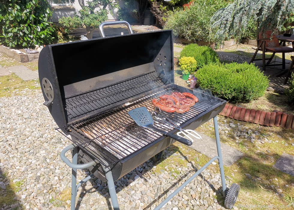 |
Roisin was off for the week so the good weather couldn't have arrived at a better time. We took full advantage of it by going away on day trips, having nice walks in the countryside, exercising, catching rays and of course indulging in a few BBQ's. We both don't eat much red meat anymore and haven't done for the last few years, I tend to stick to chicken, turkey and fish however every now and again I go back to the red, after all we still need our iron and a BBQ with just white meat on it just doesn't seem very traditional. So for two days in a row we had burgers and beef sausages along with salad, we semi-cremated the meat which is our style and it tasted absolutely delicious. I loved cooking on the BBQ, so hot, no t-shirt on, heat radiating off the concrete in the yard like a mini urban heat island, at times it was stifling but I was loving it, this was what Summer was all about.
Yet there was one thing missing to complete this mid Summer fantasy, a proper thunderstorm day. If you read my last chase report you will know that Roisin and I both intercepted a thunderstorm over Ballymena with overhead lightning and flash flooding, I managed to get a few structure shots of the storm from Gulladuff, we both loved the thrill of the chase and in awe of the sudden power of nature, however the whole event seemed to be over all too soon, it was a nice little fix but it didn't settle my rattled chasing nerves, I needed something bigger or more photogenic. If you are not into storms, or anything in nature for that matter, in a major way, you will never understand. When you are deeply passionate about a subject, and literally count down the days all year for it's return, it literally does become a major part of your life and you become mentally and emotionally involved in the subject, that's just the way I am when it comes to nature and this mind-set also applies to auroras, NLCs, comets, Winter events and other subjects I'm interested in.
Photography of the night sky and of Irish storms isn't a hobby for me, I would find the that word insulting, that implies something passive that's only indulged in from time to time then forgotten about as other things in life take over, this isn't the case for my interests. This is a full blown passion, at times if I'm honest it can lean into the borderline obsessive category. I live for this stuff, this is my drive, my calling. If it wasn't for the night sky (97) and a funnel cloud (2007) my life would be completely different, I wouldn't be typing these words on my computer for this website which wouldn't even exist. It was those two encounters which changed my life forever, I was hooked and my life has never been the same. I literally spend all Autumn and Winter waiting for the next Spring and Summer storm season.
My Dad is a fisherman, that's his main passion, every Spring he counts down the days to the fishing season, and to the famous May Fly. For several months in advance he plans everything out and makes preparations as part of the build up to the event. Sorting out all his gear, patching up the boat, picking his holidays off work, and buying various gear he needs to add to the experience. This isn't just fishing, it's an experience, it's an adventure. It's the same with me during Spring and Summer except my fish is a thunderstorm and my Salmon a large funnel cloud. Dad casts his line into the water and I cast mine into the sky, our quarry is different but the experience and build up to the big catch is the same.
If you read my last report you will also know how dreadful this storm season has been. We have had only a few set-ups, most of them turned out complete busts, a recent trip to Mullaghmore in Co. Sligo was a bust on the biggest event of the year which didn't help my morale, and I've chased on many minor days on the hunt for one decent photo opportunity. The pickings were meager, nothing contented me, it didn't even come close to the standard I have. Storms were few and far between and they happened they were weak, ugly, very high based or elevated, and on the worse days the atmosphere was capped or had issues with dry air, we lost three major events due to these atmospheric mishaps.
So here I was enjoying another hot high pressure period and this time I did some personal work on myself and changed my mind-set. I decided nature was going to do what she wanted no matter how I felt about it, so I came to the conclusion that the season was finished, I would just mark it down as my personal worst on record and move on, maybe when the dark skies returned the aurora season would make up for it. I still had half of July and all of August remaining so who knows, maybe nature would throw up a late 'fishing trip' before the season ended, I felt more at ease and just accepted the situation. When this warm spell arrived I paid close attention to the models which did show several days of big energy however this time I wasn't fooled, a week out and I saw the tell tale signs of capping so it looked like the big energy days wouldn't even produce clouds, never mind precip, so I kept an eye on it as we got closer to the time, then a few days later a major change happened and it looked like a significant thunderstorm outbreak was on the way!
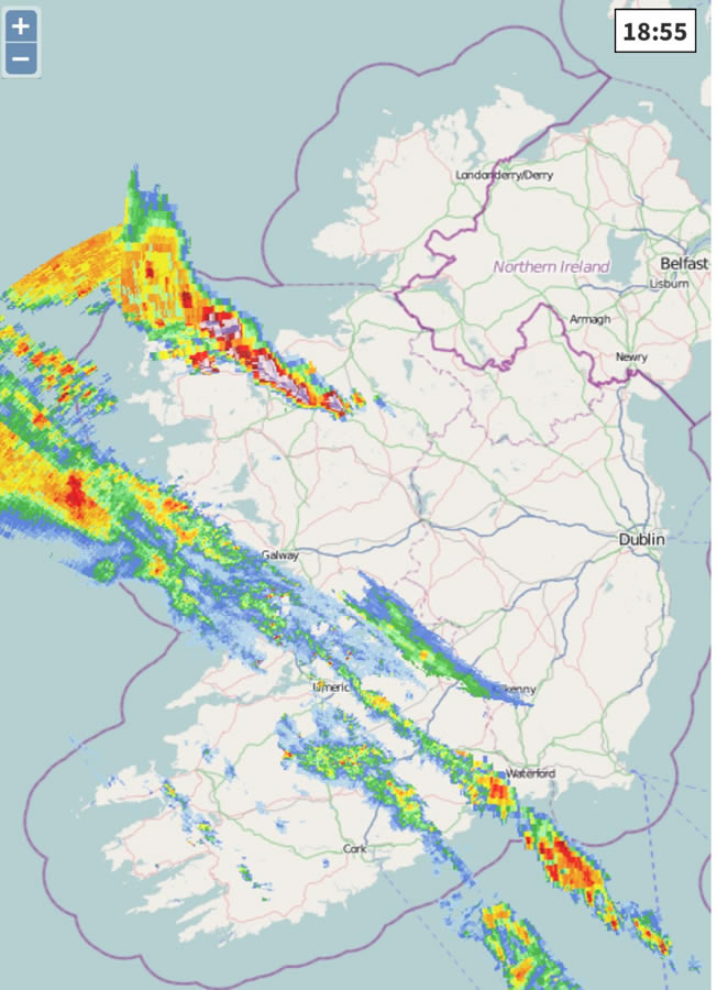
Sunday July 13th was showing a particularly strong set-up with a warm moist unstable SEly flow at the service. Over the SW of Ireland an upper trough was approaching ahead of a slow moving cold front, it was this combination which looked to be the main source of lift for any storms. Cloud top temperatures were anticipated at -50 degrees C (matching the epic 2023 season) with MU CAPE values of 1000-1500j/kg, instability values varied somewhat depending on model and type of CAPE, GFS was indicating over 1800j/kg while other higher resolution models were going for well over 2000j/kg. In addition to this there would be 40-50 knots of 0-6km shear and later in the day 40 knots of 0-8km DLS would come into play over the W coast and Atlantic areas. This all meant the potential for powerful thunderstorms. ESTOFEX had issued a level 1 for W Ireland for heavy rainfall and hail and within their text they mentioned multicell storms with a chance of transient supercells. In a nutshell highly organized storms which could become potentially severe.
There was a capping inversion in place however it was expected that the cap would erode and rapid thunderstorm development was anticipated. The night before I took a deep look at the models, I really wanted to chase and didn't sleep much. I was up late studying charts trying to work out the best course of action and the probability of being in the rite place at the rite time. The best overlap of all these conditions with deep moisture and proper dew points for storms looked to be over the province of Connacht which covered the counties of Galway, Leitrim, Roscommon and Sligo. Any storms were unlikely to go much further N despite some models showing cells going all the way up to Fermanagh and Donegal, but it was obvious to me that the W was the main target. However where would be a realistic place to target to see action? I couldn't go all the way to Galway, I suspected the best risk zone was between Galway and Sligo, I was hoping the N part of Sligo could work out, that would mean going to our favourite location of Mullaghmore for the second time this season, it would be great if that worked out, it would just be far enough W to see something and would place me in the N most part of the risk zone.
I went to bed late that night and only slept on and off thinking about storms and the up coming chase. I got up early the next morning and all the parameters were still great and weather warnings had been issued for all of Connacht, this was one of the best set-ups of the year. Yet here I was second guessing everything, I had two concerns, one was what if these storms turned out to be elevated, after all they would form from an EML associated with a warm plume, if they were elevated structure chances were very low and so this would be a wasted trip even if there was plenty of lightning. My second concern was the cap, what if the cold front didn't engage and the cap didn't break?, this scenario already had happened several times this season resulting in busts, the Mullaghmore event being the most recent, my morale would be completely broke if I drove the whole way there for nothing yet again. So amazingly I talked myself out of chasing. This was going to be another bust, hyped, and elevated garbage, I just knew it, I would be better off staying at home and enjoy the warm weather and save money.
But it wasn't that easy, I could think of nothing else and the lure of the chase was calling me, I knew if I didn't go I would be torturing myself all day looking at radar and wondering what I was missing. This time I decided to let fate decide, Roisin was having breakfast and asked ''where will we go today?'', I said what about storm chasing?, at first she was unsure, it was a long drive, and another hot day and we would have to keep our dog Rhua cool, and what if it didn't work out?, then she asked where would the storms be?, and when I told her she loved the idea of the location. That would mean great scenery and a lovely drive all through Fermanagh to Sligo, I said we could stop off at many places along the way to explore and walk and if any storms happened then it would be a bonus. Roisin loved the idea and just like that we were now going chasing.
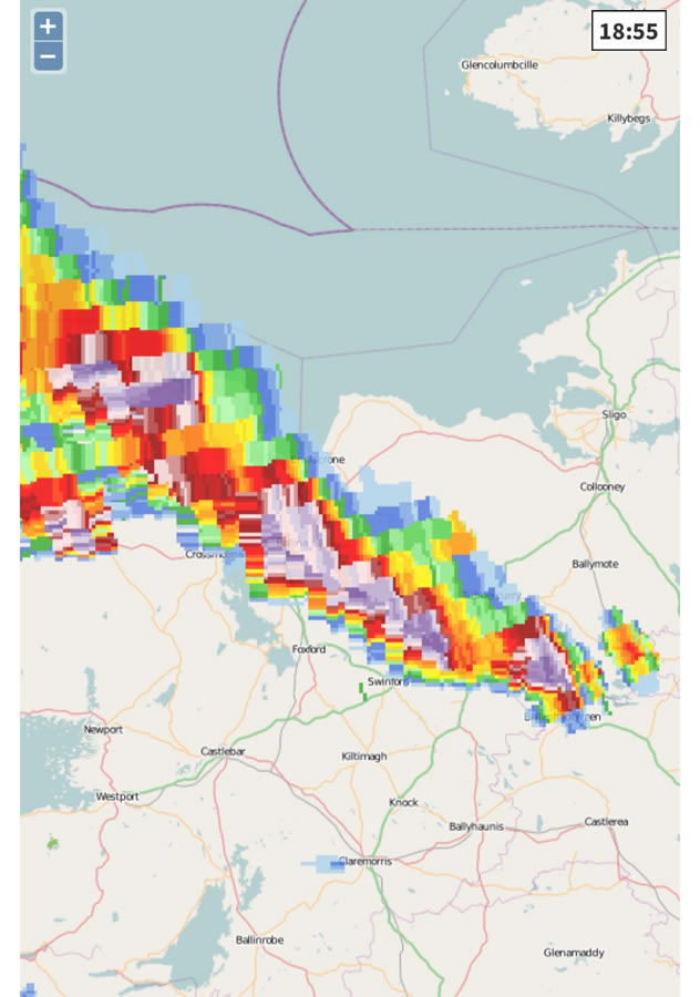
Models varied on when storms might fire and location, it seemed the late afternoon to early evening was likely, 4pm to 7pm approximately. However only two models showed cells at Mullaghmore, the others showed nothing at all, this was concerning. It also meant we would need to go further S than usual so I studied a map of the area and re-examined the updated models. The AROME was showing big cores of a storm over S. Sligo by late evening, in fact, it was showing it between 7pm and 9pm quite late in the day, if the model was correct then that could work out for us, a map showed Rosse's Point as an ideal target area on the W coast but just outside the town of Sligo itself, a scenic spot and popular with tourists, I had only been there once before chasing many years ago so only had a vague idea of the area so this was the plan. Positioning was also important with highly sheared storms, I wanted to be E of any cores in a SW-NE moving storm so I can stay out of the rain and observe structure and this location seemed perfect.
A late evening storm intercept at Rosse's Point was the plan, we were putting all our trust in the AROME, I admit I love all the preparations before a chase, working out locations and a thorough examination of all weather models, it's good fun, however at the end of the day it's nature who decides what happens and it's this aspect of the chase which makes storm photography exhilarating. I found out that none of my other chaser friends could make this day due to other commitments so it looked like it was just Roisin and I, actually I didn't even know if anyone else in the country chasing so I felt an obligation to do my best. Roisin and I bought in supplies, filled numerous flasks of water, made up hot water for tea, got Rhua's dinner made, and had a light lunch at home before leaving so we were well prepared.
It was 14.30 when we hit the road from Cookstown, we planned on taking turns driving to break up the trip, Roisin was driving first which gave me time to start filming a vlog to document the day. This was a combination of a road trip and storm chase, we would make the day of it no matter what happened. Rhua was content buckled into the back seat on a cushion and outside the blue sky was gorgeous, the sun was shinning, and the car was already reading 26 degrees C, it would get much warmer later, highs of 28c to 30c were expected in the W where we were going with greater humidity, however I expected the sky to cloud over soon in the W ahead of the front which might cool us down. The only sign of trouble in the sky were a few harmless sections of cirrus far ahead of the front but to the non sky watcher their presence would have meant nothing.
I wasn't expecting anything to happen until much later, if it all, so I asked Roisin to take her time, there was no rush. Then suddenly we entered the open landscape on the Omagh road and there was a solitary tower dominating the sky, it looked far away, actually over the Atlantic more than 100 miles away, I couldn't believe it, that tower looked huge and solid and as we watched through the windscreen it leaned over and formed a solid anvil, I knew by its size and quality of its appearance that it had to be a strong storm. I got a text from Colleen Webb who was monitoring radar from home saying storms have already broke out off the W coast of Ireland, we checked our phones and sure enough there were c-gs firing both inland and over the sea, this was much earlier than I expected and it was a great sign, clearly the cap had broken, this day was for real, it was happening and with that news we increased our speed as we drove SW.
Once we passed Omagh we had a clear view of a massive row of thunderstorms far away to the SW, a combination of anvils and towers, they all looked serious business, you didn't need radar to tell you those were big storms, they still looked far away over the Mayo area and were producing prolific lightning. I was excited but tried to keep a lid on it as I suspected those storms and the big tower we saw to be elevated as they just looked too tall from this range (I was wrong, they were surface based!) but I was happy knowing strong storms were happening. We stopped in Kesh for a break and picnic then got back on the road, we passed through the scenic lakes of Co. Fermanagh and went straight to our old favourite hunting grounds at Mullaghmore.
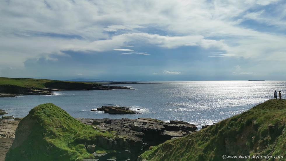 |
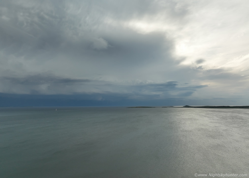
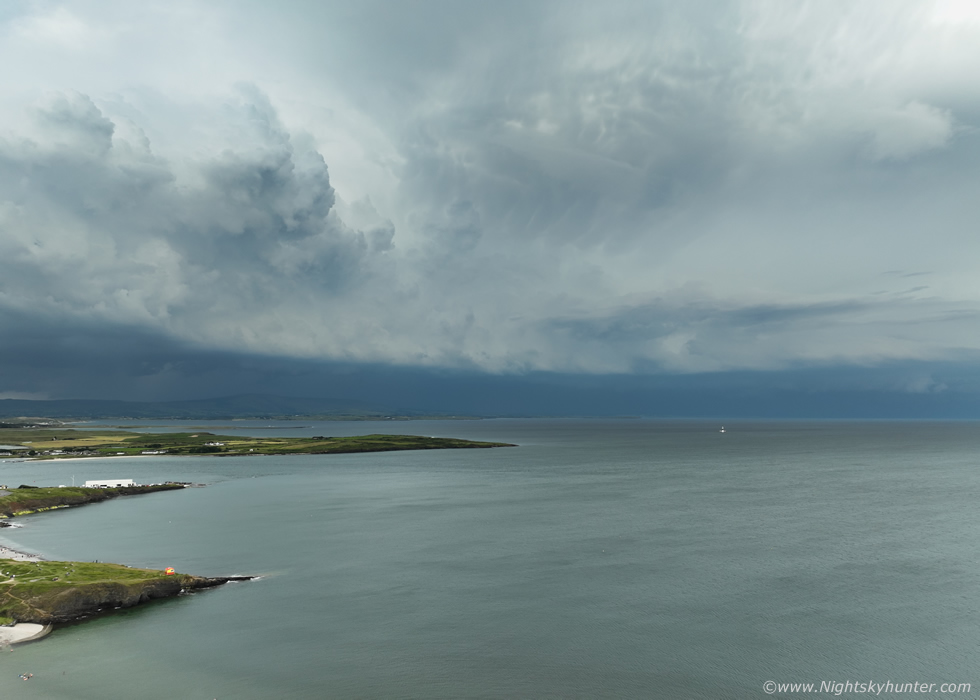
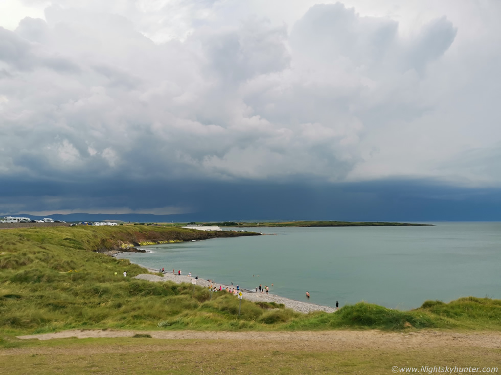
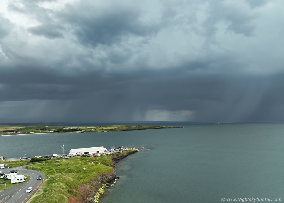
Mullaghmore was busy, full of visitors and coaches with tourists from all over the world, Roisin, Rhua and I got out for some fresh air and a walk. My goodness it was hot, it always was stifling here due to the marshy dry grass and moss which seemed to radiate heat back upwards into your face. It was still great to be here looking over the W Atlantic with Classiebawn Castle in view. Straight in front of us miles away in the distance through the low haze was the most powerful thunderstorm in the country in perfect view. This was the multicell cluster that was causing flooding, prolific lightning and knocking out power to homes rite now between Mayo and Sligo. Moving L to R, towers feeding into the back and anvil sheared across the sky, I said to Roisin if this was night time the sky would be lit up with lightning flashes. This storm was our target, it would be slowly moving N ahead of the cold front, with luck it would hold out and stay organized until later, I didn't see why not, the CAPE was present until sunset and if anything the DLS would be getting even stronger as the day went on.
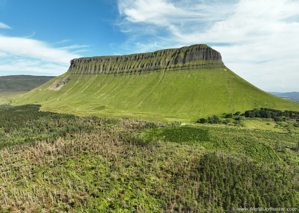 |
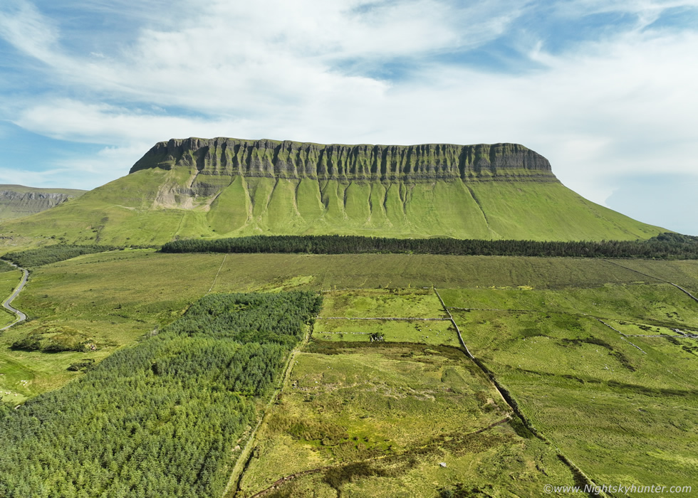
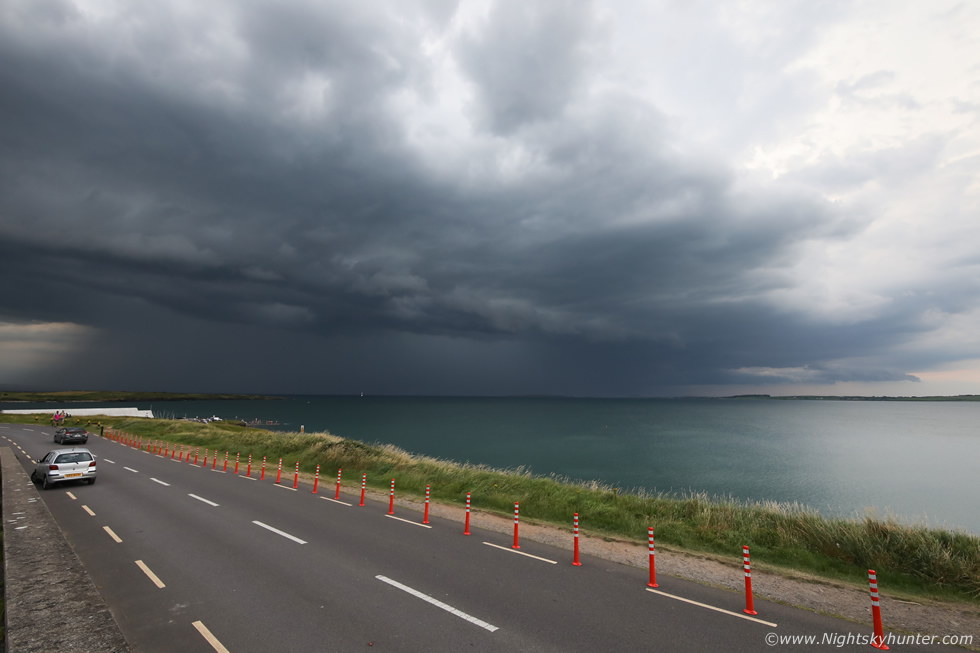
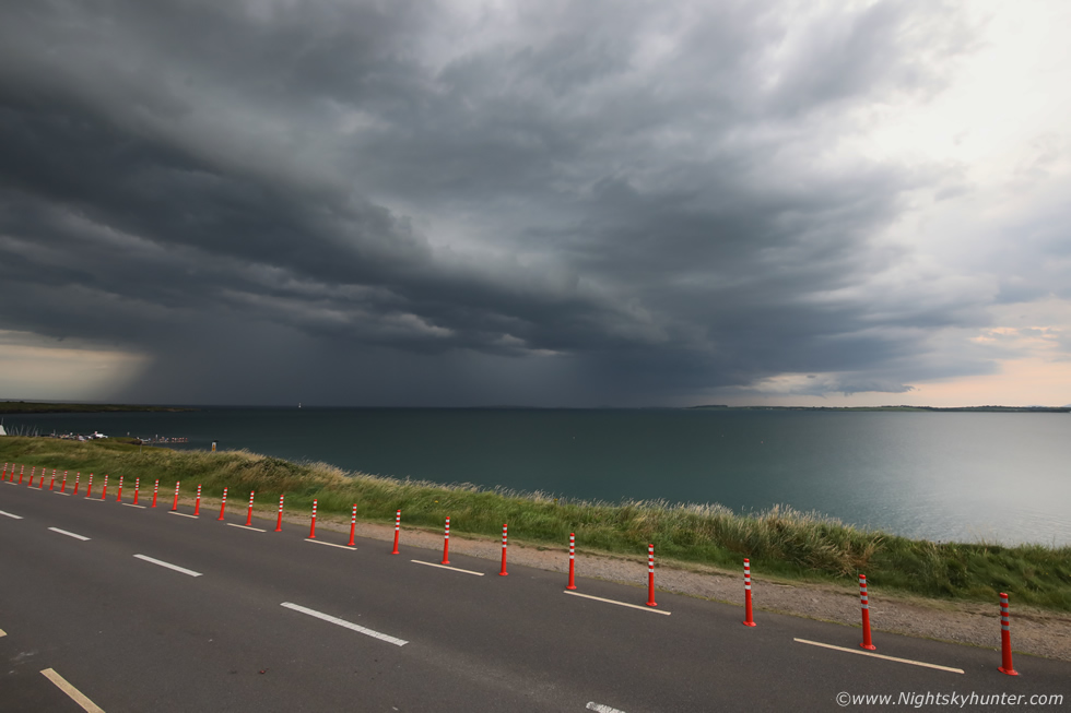
Roisin and I both felt that Mullaghmore wouldn't see a storm today, we just weren't feeling it, we needed to be further S so we got back on the road. From here on we were in road trip mode just trusting our instincts, enjoying the scenery and killing time. As we drove S we glanced to the W when we entered a clearance and there was the legendary Benbulbin in Co. Sligo, when you see this mountain up close it demands attention, it really is a striking, dramatic, and beautiful sight. We had seen it many times over the years while chasing here but always at a distance and it had been on my wish list as a place to film with the drone so this was going to be the day. We took a random country road off the main and began driving towards it, the view through the windscreen was amazing, we couldn't wait to get pulled over for images. We couldn't wait any longer so I pulled in at a grass verge and we got out to take in the view, I had the drone in the air in no time.
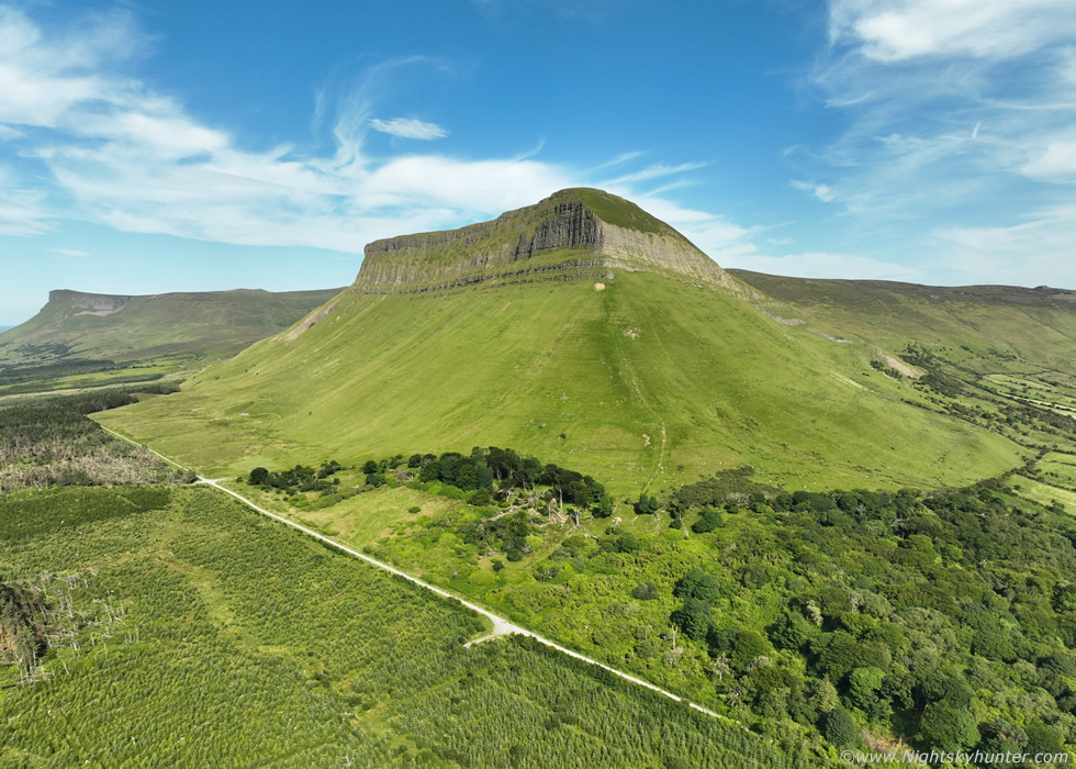 |
This mountain was formed during the last Ice Age and is over 500m tall, however it's dramatic structure really makes it stand out from this beautiful landscape, the entire scene was like something from a fairy tale or block buster movie. I said to Roisin that even if the storms didn't work out experiencing this alone will have made the trip worth it.
 |
The wind was blowing quite hard which was really taking its toll on the drone's battery however I made use of all the air time I had and got a selection of images and video clips. The sun was hot and the trees hid our view of the sky to the SW so for all we knew the storms had died out now, and anyway we had no phone signal to check online. Final image before landing the drone just as a formation of German tourists past us after walking from the mountain, they looked thirsty. We plan to come back to Benbulbin in the future, I would especially love to capture it in the snow, but that's another day and another time of year, now our attention was back on storms, it was already evening time so it was make or break and anticipation was building.
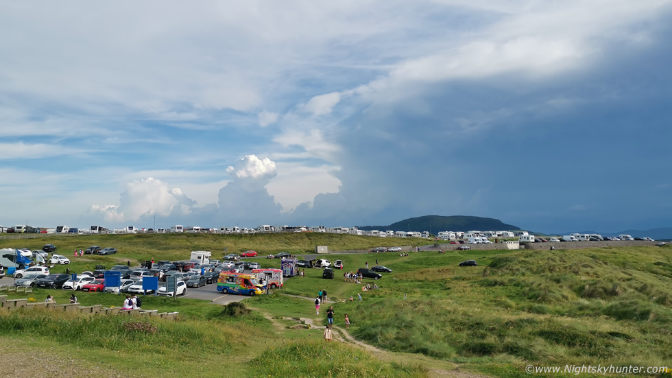 |
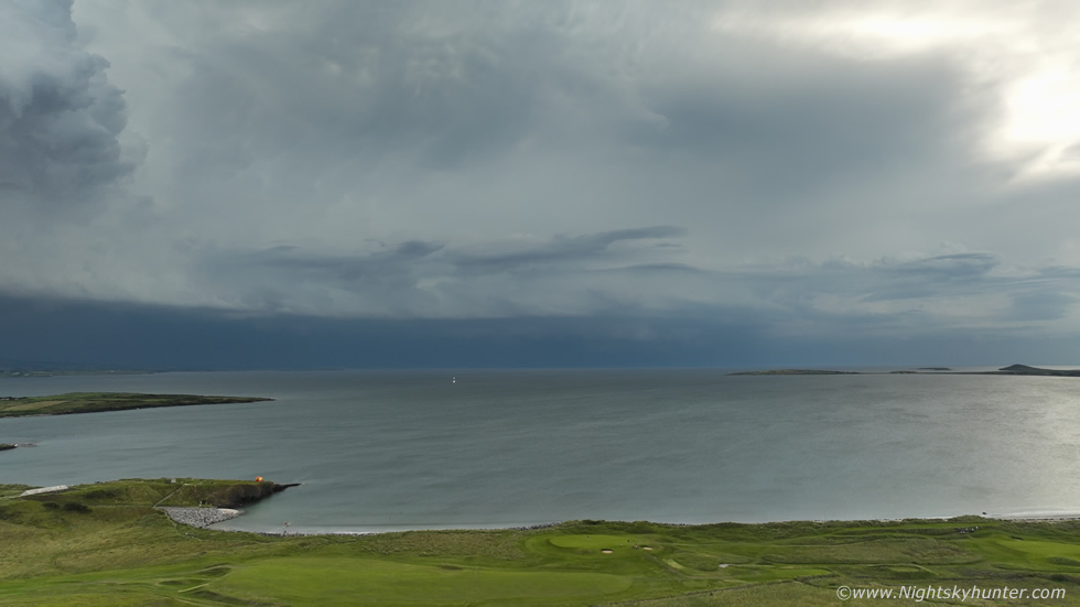
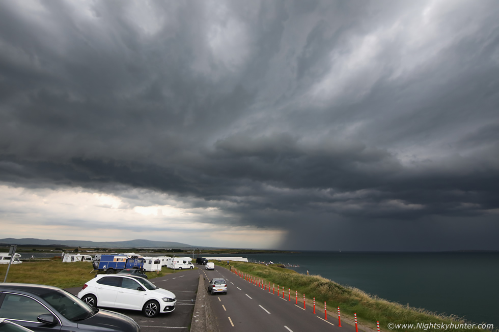
Once back on the main road still driving S we could see big convection crossing the sky in front of us and we knew this was our chance. Just before Sligo town itself I took a random road to the right and ended up at Rosse's Point, the exact target area I had picked on the map this morning but which I had just found by accident while driving, it looked like fate had brought us here, this was meant to be. Upon arrival the place was packed with mobile homes, tourists, families, teenagers, ice cream and hot food vans, the place was thriving with activity. Roisin spotted a new anvil to our S and literally within ten minutes it had spread out across the sky merging into the bigger storm. New towers were building behind it and things were looking good. I don't like crowds so we walked away from the busiest section onto a grassy hill which offered a fantastic view to the S-W, there we sat down on a summer seat and took in the view.
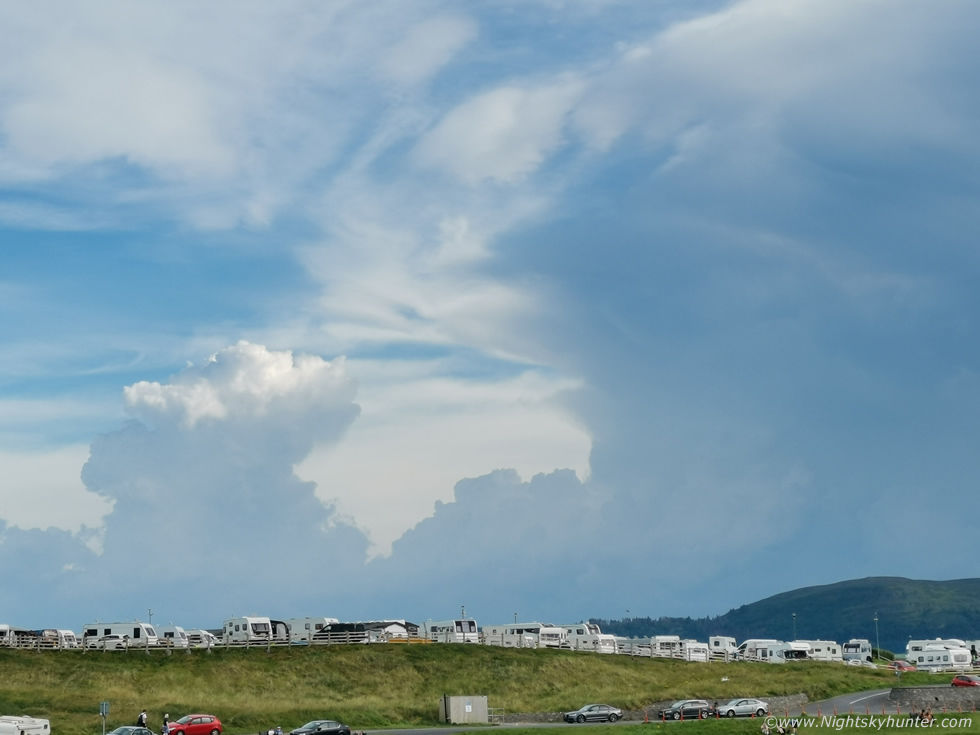
We had no internet so knew nothing of the current state of what was happening but we did know that this was the main storm in the country which had literally been producing lightning for hours on end. It was 18.30 and the air was warm, in front of us was a massive multicell storm with new towers bubbling up at the flank. One tower had a lovely pileus cap, we turned around to admire the ocean view then looked back at the tower and the pileus was like a different cloud, the tower had lifted it up and punched rite through it and extended upward above the pileus by almost 10 degrees of hand measurement all within 40 seconds!, I knew this was an excellent sign, anytime I've seen pileus on a storm day it usually ends up being good, and I said as much to Roisin.
We sat on the seat, everything was relaxed, I filmed a vlog and took images with the phone, I was quietly waiting for the rite time to get the drone in the air. Roisin and I knew by just looking at the clouds that this was a thunderstorm but we couldn't understand why we were seeing no lightning or hearing thunder. As it turned out the storm was further away than we thought hence thunder was out of ear range so far and all the lightning was intra-cloud which was why we saw no c-gs. It was time to be patient, the storm was moving L to R and edging closer to us.
 |
3x optical zoom using the phone into the primary updraught merging with the anvil and new updraught erupting behind it. I only discovered later that my phone footage had detected lightning rite now going on inside the updraught on the right. I noticed interesting structure through the low level haze, the main updraught was tilted over and even appeared to have a vault, I didn't want to jump to any conclusions yet but I suspected brief supercell traits at this stage at the back end of the multicell cluster. The storm started to edge in and we began to see a long dark base appear above the distant mountains and extending to the right was the faint outline of a forming shelf cloud out to sea. The storm was getting closer and bigger with continuous new updraught growth, I knew we were in business. I walked away from people into the grass, waited for the correct moment then got the drone in the air.
 |
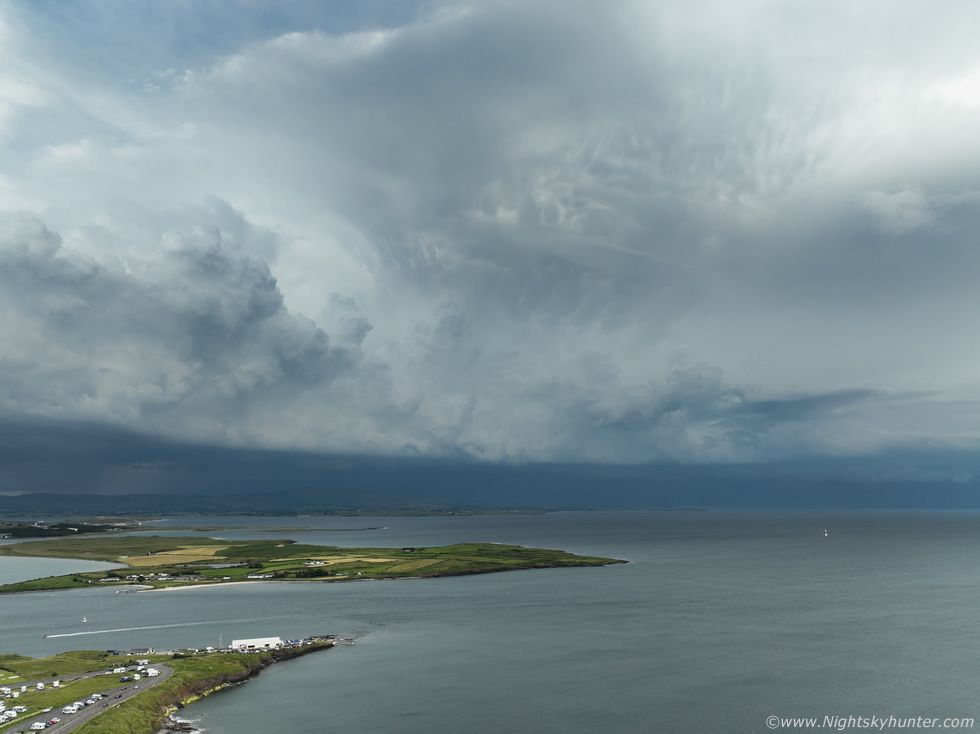
Cirrus from the anvil turned the sun hazy and offered us some respite from the intense sunshine but the breeze still felt warm and comfortable. It was approximately 7pm and the massive storm had come into view, this was the beast which had been flashing for many hours from mid afternoon to late evening, literally hours of lightning and finally it was here at Rosse's Point to great us. At this moment in time I knew we were seeing something exceptional and I was overjoyed knowing our chase wasn't in vain, we had scored big time, the long drive and the hours of patience had paid off, now we were going to savour every moment.
Drone hovering at 120m looking SW towards this enormous multicell thunderstorm. This is the business section of the storm looking at the principle updraughts and flanking line. On view was a long low dark base, above that base rock solid updraughts billowed up and expanded in real time, the anvil then sheared to the right down wind out of frame out to sea. The area between the tallest updraught and anvil intersection had an interesting shape, like a large curved bracelet which may have hinted at rotation, this was a persistent feature for a while. Entire storm moving from L to R and creeping towards us.
 |
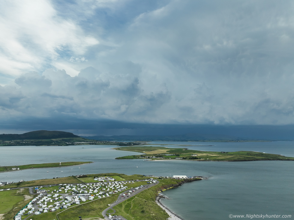
Netweather.tv radar grab from this approximate time period. The storm is sheared out not dissimilar to a supercell, in fact, the western post part of the precip is beyond radar coverage and has missing data, I suspect the precip there was even broader out to sea where the anvil shield ended. Massive multiple white cores can be seen in the area which faced us. At a very rough estimate I would say this storm was 80km in length and that's just the precip area.
 |
Panning drone 90 degrees to the right looking out W where the anvil extended far out over the ocean with a low shelf visible below. Notice that little white speck of a lighthouse, that would soon become a focus point for me.
 |
Panning back to the S-SW at the solid flanking line. I've been trying all Summer to get storm structure and finally I got it. This was the largest and most significant thunderstorm event in Ireland to date and for us to be here to see it was like a big weight being lifted off my chest. So much effort, so much diesel and expense, so much energy had been put into this season from big days to the smallest in the hope of getting a decent storm and finally it happens, the wait was worth it. Plenty of structure which I love to see all on view here, the updraught base, flanking line of towers, and long low shelf cloud lurking half hidden in the shadows ahead of the precip core. The storm was still over 20 miles away from us yet look at its size in the wide angle camera, it would take 2.5 camera fields to get it all in even at that distance.
 |
Radar zoom looking into those massive sheared cores, it really doesn't get much better than this.
 |
Honestly this storm was a beast, look at it with the headland and mobile homes for scale and complimented by beautiful structure. Later when I got home I would see dramatic accounts from those who lived under the storms core. One resident said ''it was the most electrically active storm I've ever seen'', another said it reminded them ''of the storms they seen in France'', and a well known amateur astronomer I know said it was producing overhead in-cloud lightning every second constantly with terrible rain and strong winds. The drone picked up in-cloud lightning inside that updraught, if this had been twilight we would be seeing one hell of a light show.
 |
Inside I was celebrating, this chase was already a total success, we had a road trip, adventure, picnics, explored Mullaghmore and Benbulbin, and the icing on the cake was this thunderstorm, the event of the year, this was the perfect day out. Roisin was enjoying herself too taking in the wonderful view and admiring the approaching storm, this was her second storm encounter within the last two weeks. Some people might say would I not rather be under it seeing the close range lightning and flooding rainfall, my answer is always a resounding no. Although that aspect has it's own appeal and excitement I'm a structure person, my perfect chase day is one where I can be at the side of the storm in dry air taking in the storm's structure where I can enjoy it's evolution and shoot footage or time lapse at my leisure, this is exactly how today panned out and Rosse's Point was perfect.
 |
90 degrees pan to the right again to take in the down shear anvil/forward flank crossing the W Atlantic. The entire storm looks like some kind of merger between multicell cluster and squall line. If you where on a boat out to sea you would be getting a good view of a shelf cloud through that haze. The storm was getting closer, the sun was darkening more, and the cool outflow was mitigating the heat toa nice comfortable level. We had a bit of walking to do to make it back to the car so we began the walk back incase we needed to take shelter so I landed the drone and we made our way across the site and through crowds, many of which were oblivious to the monster in the sky in the distance.
 |
Before we made it to the car I got distracted once again by the mean skies presented by this storm. Thunder began to rumble, I held my fist in the air with delight and Roisin gave a 'wow', finally the storm had got close enough for us to begin to hear the rumbles. That updraught region I enjoyed so much had now developed it's own heavy precip core in classic back-building multicell fashion and had become a new storm at the back of the cluster, I took this phone snap, the core was dark and blue under the brilliant cream towers aloft. More thunder rumbled, the storm began to evolve rapidly and I wanted to put the drone up one more time, however I wanted to find some interesting foreground to go with it, then I recalled the lighthouse I seen earlier, my heart began to beat faster, if I could get the drone out to that it would be an awesome scene, but standing on the dunes didn't feel drone friendly, the wind was strong blowing off the land, now more from an Ely direction, Roisin thought the lighthouse would be great but not to risk the drone as the wind wasn't good and I might not get it back. However, I was confident and knew from years of experience of flying out over the sea to film marine vessels in all weather conditions that it could be done, I just would stay low and let the land partially block some of the wind.
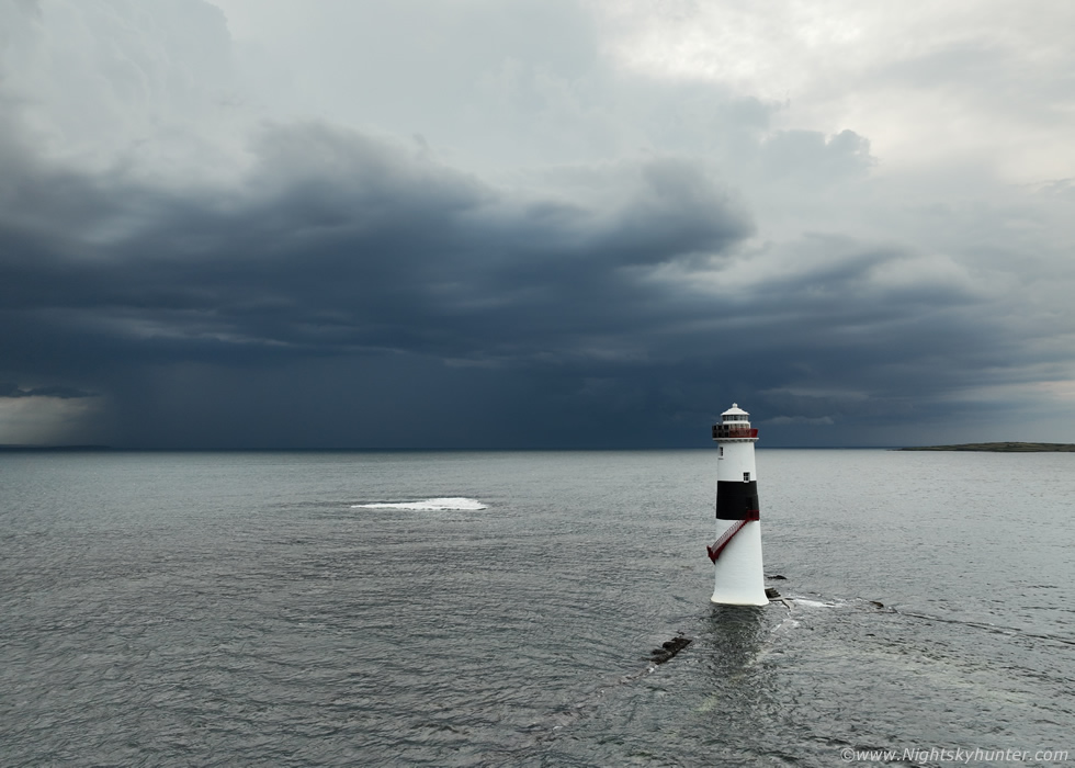 |
I sent the drone out skimming fairly low over the water, a strong constant breeze was blowing off the land from my left while another head-on breeze was clashing with that in the form of outflow from the storm but I was determined to reach my subject, when the drone arrived I was buzzing, this was something I had never expected to see this day. The storm had rapidly matured and was rumbling away, the clouds were black and so too was the precip core which had a strong white reflectivity on radar. At the mid levels cool looking cloud structures fanned outward to the N/NW while a compact shelf feature was forming on the W side. Above all this could be seen the thunder heads far above the mayhem below.
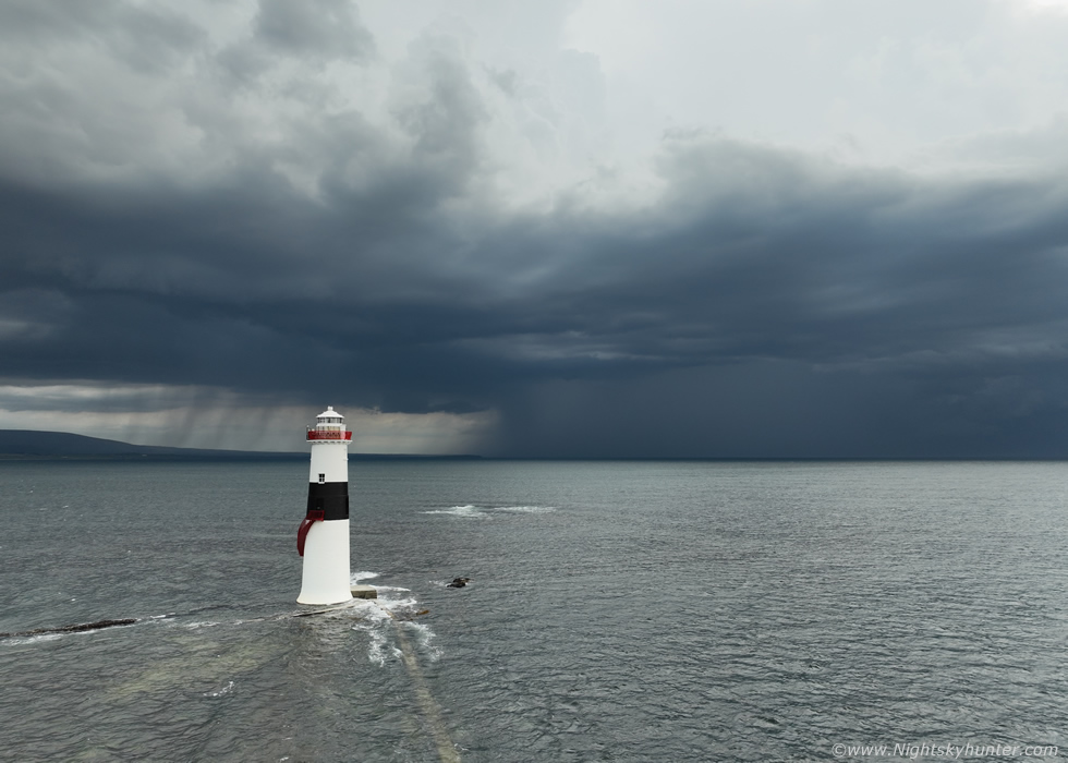 |
This was the first time in my life that I've captured a thunderstorm with a lighthouse, I was savoring every second of the experience taking stills and video sequences trying to get as much from the battery as possible in the wind, also precip was breaking out to the left and getting closer and I didn't want the drone caught out under sudden convective rainfall, however for the time being I was in Heaven. Big core on right and base on left, this is called Black Rock lighthouse, it's famous in the local area and has a lot of history. I was recording video hoping to capture a c-g hitting the sea, if it happened it would be an epic moment, however all the lightning was high up within the towers so no ocean strikes occurred, I wasn't disappointed, getting mean storm structure with this foreground had just made my entire season.
 |
I wanted to drop the drone really low over the water and tilt the camera up to accentuate the size of the lighthouse against the storm however I kept loosing signal which frustrated my efforts, I had great line of sight over flat water so perhaps it was wifi interference from the area, so this altitude was all I could get away with while keeping a signal, but it worked.
 |
Panning left along the base of the flanking towers on the multicell line which were now producing precip overland and lot closer to where I was located, you can see hints of a shelf structure developing.
 |
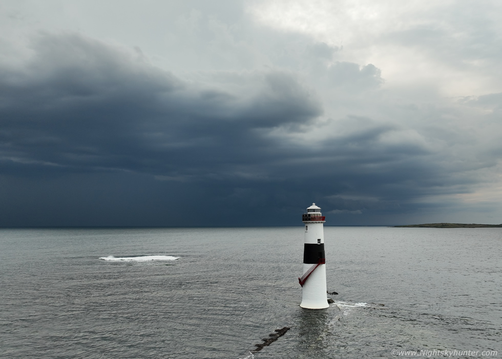
Flying backwards towards land racing to land incase the rain got the drone. Nice sense of scale here with massive storm dwarfing the lighthouse. Check out the circle of light or hole along the base to the left, it wasn't rotating, just a strange oval gap. I actually love all these lighthouse images, these will be rare additions to my storm collection. I intend on coming back here in the future to get that c-g strike and more structure from this wonderful location.
 |
The drone arrived back, I had enough battery for a few more images, massive curtains of precip falling now about to engulf the lighthouse. I landed the drone and packed it away as more thunder rumbled. This one moment has made up for the lack of storms all year, it just goes to show that one day can make a season. I was celebrating internally then made my way back to the car where Roisin and Rhua were watching the storm with a cup of tea.
 |
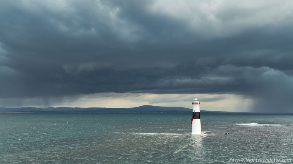
We were parked on high ground above the road which flanked the sea and had a great view of the storm. I decided the scene deserved to be shot with the DSLR from the ground for the best quality, this was 15mm wide angle on full frame of the storm and shelf. Pockets of hazy sunshine would illuminate green areas of the sea which contrasted with the dark clouds. I set up my phone on the wall with mini tripod and recorded video incase of a lucky c-g. Thunder was sporadic and all lightning went unseen above.
 |
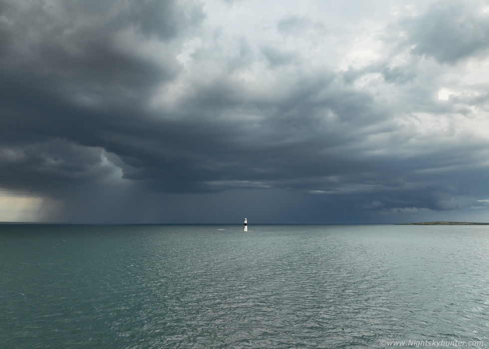
Moving more out to sea and beginning to wind down with long gaps between rumbles, the storm was easing and becoming outflow dominant and was on borrowed time, but in it's final moments it made for a mean sight as it clipped Sligo Bay.
 |
Final image with wide angle tilted upward showing the interesting detail in the clouds with those streaks sweeping out from the base due to the low level shear. The storm base got higher then weakened then silence, the outflow breeze was gone and it was warm again, the only sounds were from the tourists once again, all of whom had escaped the wrath of the storm, it was now ocean bound. The time was 8.30, we had been watching it for over one and a half hours from this location and we never experiencd a drop of rain on us, perfect positioning. I celebrated with a well earned brew and a few snacks.
I had got what I was after, that special warm glow one gets when you have experienced a great storm day and something special, that moment of awe and happiness that's so strong I didn't want to leave, I could have stood there until darkness absorbing the energy of the day. I've been after that feeling all year and finally got it, I'm so glad we decided to chase and to think for a while this morning, which seemed a life time ago, I was considering not chasing worried about a bust, it just goes to show to never give up. We began the drive home, this time the drive was easy, it always is when you never come home empty handed.
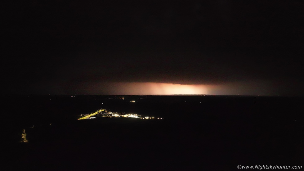 |
We where back home for 11pm, I was already charging batteries and downloading footage onto my computer as there was a chance of more storms the following day. I was checking online, looking at models, going through my latest footage, sipping a cold drink, it was a warm muggy night however the convective potential was not over yet. Elevated showers were expected to move in over SE and E N. Ireland, the thunder risk was low but not ruled out, I didn't pay it too much attention to be honest and I was also still in the zone from the earlier chase. I got a message from Colleen Webb about cells moving in, they approached Belfast and turned into thunderstorms. Night time lightning over the city, reports came in on social media, I watched the cells on radar moving N slowly with c-g sferics, I thought Belfast is just across the lough to the E as the crow flies from here, I might be able to see that lightning.
I walked upstairs and opened the skylight window on the roof and peered through the darkness to the E, flash!, yessss!, I could see those storms, a minute later another flash, that was a nice treat to come home to, absolute icing on the cake after today's success. I went back downstairs to the computer and continued going through footage, the blinds were open, I left the distant storm to it, then I saw bigger flashes coming through the window, I mean really powerful bright flashes, this was getting interesting, I checked radar, the storm was now over the Antrim area, I couldn't ignore it any longer, I went out the back and got the drone in the air. No sooner had the drone gained in height when lightning lit up the sky. At first I was using wide angle and night mode and was catching big areas lit up by the flash, here's a video grab above of one of those. Drone facing NE, then I went to normal video and zoomed in approx x1.8 to x2.0 and began recording, this time a c-g struck I could see it on the screen, this was getting good.
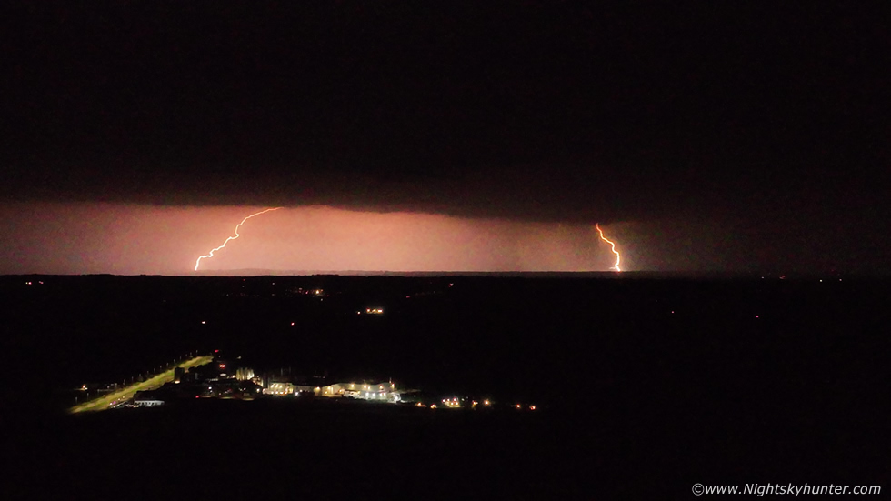 |
So I let the drone settle and began a new video sequence, the night was dead calm, silent, dark, I was standing with no t-shirt on in the warm night at 2am in the morning watching this distant surprise storm. Then four rapid flashes, two of them exceptionally bright, I watched as two rapid fire c-gs struck down one after the other in quick succession, what a treat! By the time I went to bed it was 3am, my mind never rested thinking about this well earned storm treat after my personal best chase day of the year.
Vlog of our chase to Mullaghmore and Sligo featuring aerial footage of Benbulbin, the multicell storm updraughts, the lighthouse storm and Antrim night lightning. The following day would bring another risk of storms, however I will cover that on the next report. Thanks very much for reading.
Martin McKenna
